
Buying or selling a home in England or Wales can get complicated when you discover suspicious plant growth close to your property. Japanese Knotweed is known for its rapid spread and challenging removal, often raising red flags during property transactions. If you want a chemical-free solution, a detailed invasive plant survey helps you understand the problem clearly, making your chosen method safe and suitable for your site.
Table of Contents
- Step 1: Prepare Site And Gather Essential Tools
- Step 2: Inspect Property And Map Affected Areas
- Step 3: Identify Invasive Species And Record Evidence
- Step 4: Assess Infestation Severity And Risk Factors
- Step 5: Verify Survey Accuracy And Compile Report
Quick Summary
| Key Insight | Explanation |
|---|---|
| 1. Gather essential survey tools | Assemble a survey kit including a GPS, camera, datasheets, and safety gear for effective data collection. |
| 2. Conduct systematic property inspection | Perform a thorough walkthrough of your property, documenting infestations using GPS and mapping tools. |
| 3. Carefully identify invasive species | Use identification resources and document key features of invasive plants to distinguish them from natives. |
| 4. Assess infestation severity and risks | Evaluate the ecological impact and potential damage of invasive species to prioritise management strategies. |
| 5. Compile and verify your report | Cross-reference your data with authoritative sources to produce a comprehensive and reliable survey report. |
Step 1: Prepare site and gather essential tools
Before embarking on your invasive plant survey, proper site preparation and tool selection are critical for accurate data collection and personal safety. Gathering the right equipment ensures you can efficiently document and assess potential invasive plant infestations across your property.
Start by assembling a comprehensive survey kit that includes essential wildlife monitoring tools. Your survey toolkit should contain a GPS device for precise location tracking, a high resolution camera capable of capturing detailed plant identification features, weatherproof datasheets or a digital recording app, and appropriate safety gear. Consider wearing protective clothing like long trousers, sturdy boots, and lightweight gloves to prevent potential skin contact with harmful plant species. Protective eyewear is also recommended when working in dense vegetation areas.
Careful site assessment involves creating a methodical approach to surveying your property. Walk the entire area systematically, paying close attention to boundaries, garden edges, disturbed ground, and areas with previous landscaping work where invasive plants often establish themselves. Bring a detailed site map or create a rough sketch to mark potential problem areas and track your survey progress.
Expert Advice Always carry a first aid kit and inform someone of your survey location and expected duration for added safety during invasive plant investigations.
The following table contrasts essential survey equipment with their specific function and the value added to your survey:
| Tool/Equipment | Function | Value to Survey Process |
|---|---|---|
| GPS Device | Records precise locations | Enables accurate mapping of findings |
| High Resolution Camera | Captures clear plant images | Supports robust species identification |
| Protective Clothing | Shields from harm | Ensures safety during fieldwork |
| Weatherproof Datasheets | Secure data collection | Prevents data loss in adverse weather |
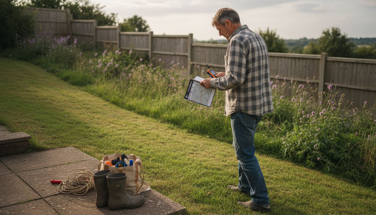
Step 2: Inspect property and map affected areas
After preparing your survey equipment, the next critical phase involves systematically inspecting your property to identify and document potential invasive plant infestations. This step requires careful observation and precise mapping to understand the full extent of plant spread across your land.
Begin by conducting a comprehensive walkthrough of your entire property, paying close attention to boundaries, garden edges, disturbed soil areas, and locations with previous landscaping work. Use your GPS device to record precise location details of any invasive plant sightings. Create a detailed sketch or digital map marking specific areas of concern, noting characteristics such as plant density, growth patterns, and proximity to structures or other vegetation. Take high resolution photographs that capture distinctive features which will help with later identification and tracking.
While surveying, look for telltale signs of invasive species like unusual growth patterns, plant clusters that differ from surrounding vegetation, or damage to hardscaping such as pathways or foundations. Pay special attention to areas with recent ground disturbance, as these are prime locations for invasive plant establishment. Document each area thoroughly, recording GPS coordinates, estimated plant coverage, and any observable impacts on surrounding landscape.
Expert Tip Cross reference your initial survey findings with local ecological databases to validate your observations and understand potential wider ecological implications.
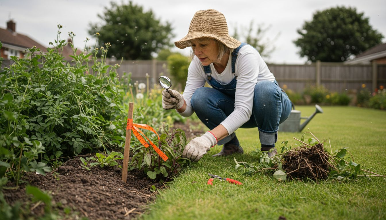
Step 3: Identify invasive species and record evidence
Identifying invasive plant species requires careful observation and detailed documentation. Your goal in this stage is to accurately recognise and record specific characteristics that distinguish these potentially harmful plants from native vegetation.
Carefully examine plant characteristics using comprehensive identification resources that provide detailed guidance on distinguishing invasive species. Focus on key identifying features such as leaf shape, stem structure, growth patterns, and flowering characteristics. Japanese Knotweed, for instance, has distinctive bamboo-like stems and heart-shaped leaves, while Himalayan Balsam features pink trumpet-shaped flowers and tall branching stems. Take multiple high-resolution photographs from different angles to capture these unique attributes, ensuring clear images of leaves, stems, flowers, and overall plant structure.
Documentation is crucial for effective invasive plant management. Create a systematic record that includes precise GPS coordinates, estimated plant coverage, growth stage, and potential environmental impacts. Photograph each identified invasive plant cluster with a scale reference like a ruler or standard-sized object to provide context for size and spread. Include detailed notes about the surrounding environment, such as soil type, proximity to structures, and interaction with native vegetation.
Expert Tip Always wear protective clothing and avoid direct contact with potentially harmful invasive species during your identification and documentation process.
To help prioritise your efforts, here is a reference table summarising typical invasive plant species found in UK surveys and the key risks they pose:
| Species | Key Identification Feature | Main Ecological Risk | Notable Property Impact |
|---|---|---|---|
| Japanese Knotweed | Bamboo-like stems, heart leaves | Rapid spread, outcompetes natives | Can damage building foundations |
| Himalayan Balsam | Pink trumpet flowers, tall stems | Suppresses native flora | May cause soil erosion near banks |
| Giant Hogweed | Large leaves, white flower heads | Phototoxic sap affects wildlife | Causes skin burns, restricts access |
Step 4: Assess infestation severity and risk factors
Evaluating the potential impact of invasive plant species requires a systematic approach to understanding their ecological and environmental risks. Your goal is to determine the extent of the infestation and its potential consequences for your property and surrounding ecosystems.
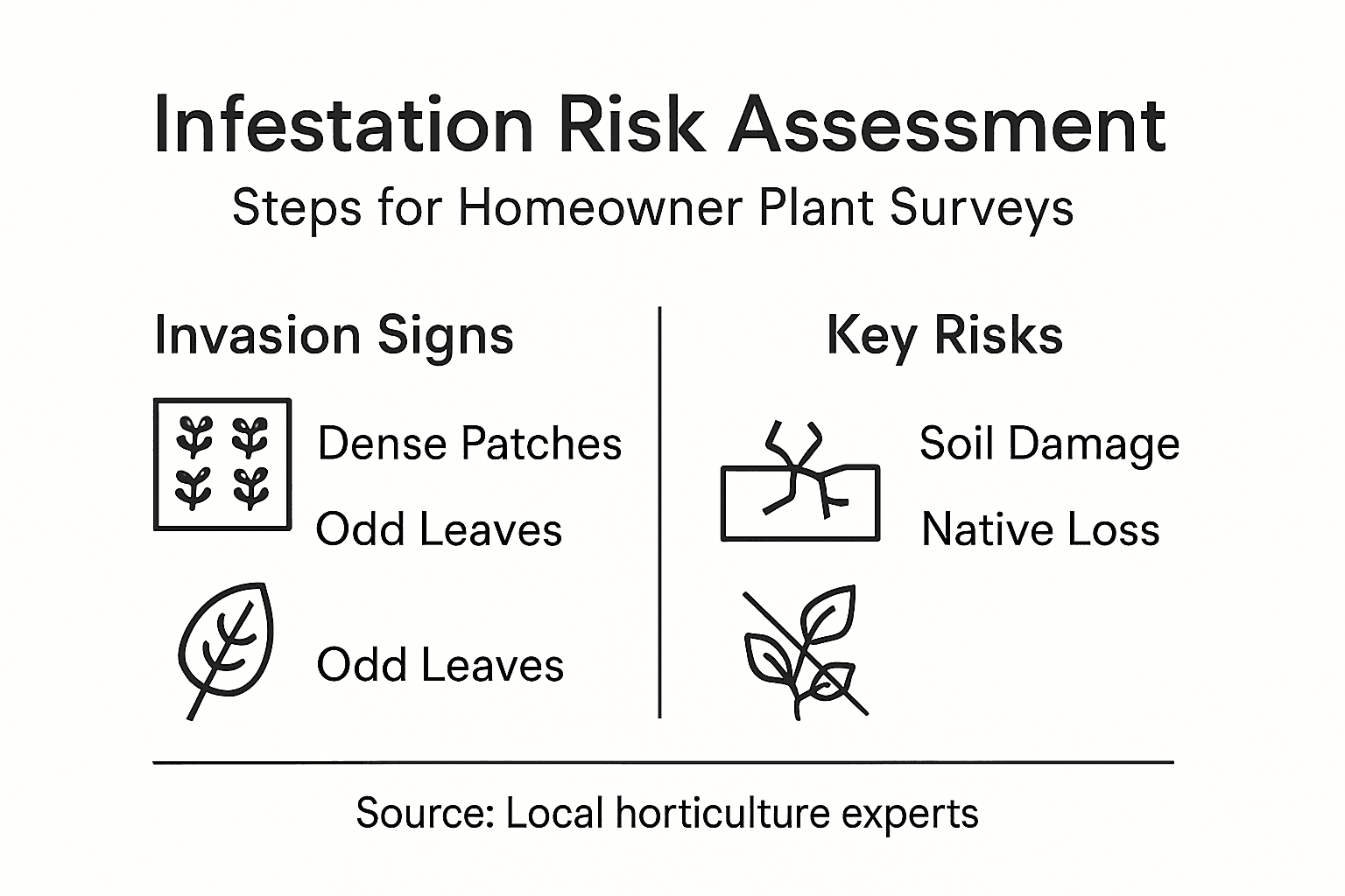
Utilise comprehensive invasive species assessment tools to analyse the specific characteristics that determine infestation severity. Consider key risk factors such as the plant’s growth rate, reproductive capacity, and ability to outcompete native vegetation. Japanese Knotweed, for example, can spread rapidly through underground rhizome networks and potentially cause structural damage to buildings and infrastructure. Assess the plant’s proximity to vulnerable structures, water sources, and sensitive ecological areas. Measure the current plant coverage and estimate its potential spread by examining growth patterns, soil conditions, and surrounding habitat characteristics.
Prioritise your control strategy by creating a detailed risk assessment that quantifies the potential ecological and economic impacts. Calculate the potential damage to property foundations, drainage systems, and landscape integrity. Consider the plant’s reproductive mechanisms, such as seed production or root fragmentation, which can accelerate its spread. Evaluate the potential long-term consequences if left untreated, including displacement of native plant species, soil erosion, and potential reduction in local biodiversity.
Expert Tip Consult local ecological experts or invasive species specialists to get a professional assessment of complex or extensive infestations.
Step 5: Verify survey accuracy and compile report
Compiling a comprehensive and accurate invasive plant survey report requires meticulous verification and systematic documentation. Your final step involves transforming your field observations into a professional assessment that can guide potential management or remediation strategies.
Ensure the reliability of your survey data by cross-referencing identification details with authoritative botanical resources. Review all collected photographic evidence, GPS coordinates, and written observations for consistency and accuracy. Compare your findings against established invasive species databases to confirm species identification and verify the extent of the infestation. Pay special attention to details such as plant measurements, growth characteristics, and potential environmental interactions that could impact the survey’s credibility.
Organise your report with clear sections that provide a comprehensive overview of your findings. Include a detailed map highlighting invasive plant locations, high resolution photographs with scale references, estimated plant coverage percentages, and potential risks to property or surrounding ecosystems. Summarise your observations with precise language that objectively describes the infestation severity, potential spread mechanisms, and recommended next steps for management or eradication. Consider including recommendations for professional intervention if the invasive species present significant ecological or structural risks.
Expert Tip Create digital backups of all survey documentation and photographs to ensure you have a reliable record for future reference or professional consultation.
Take Control of Invasive Plant Threats with Expert Support
The detailed steps in your invasive plant survey highlight the challenges of identifying, mapping, and managing aggressive species like Japanese Knotweed right on your property. Accurate identification, assessing infestation severity, and documenting evidence can feel overwhelming without specialist tools and expert knowledge. This is where professional help makes a real difference.
At Japanese Knotweed Agency, we offer more than just guidance—we provide effective, chemical-free eradication solutions tailored to eliminate invasive plants safely and efficiently. Our high voltage treatments target the extensive rhizome networks beneath the surface while our specialist teams handle root barrier installations and excavation works to prevent further spread and protect your property’s structural integrity. We also conduct thorough property surveys for invasive weeds across England, Wales, and Ireland, ensuring no infestation goes undetected.
Don’t let invasive plants silently damage your land or home foundations. Start with a precise and professional survey combined with cutting-edge treatment methods to secure your property today. Visit Japanese Knotweed Agency now and take the first step towards a safer, invasion-free environment.
Frequently Asked Questions
What should I include in my invasive plant survey toolkit?
To conduct an effective invasive plant survey, include a GPS device, high-resolution camera, weatherproof datasheets or a digital recording app, and appropriate safety gear. Assemble your toolkit before starting the survey to ensure you can accurately document any infestations and stay safe.
How do I identify invasive plant species during my survey?
To identify invasive plant species, examine key characteristics such as leaf shape, stem structure, and flowering features. Use identification resources to help distinguish between native and invasive species, and take multiple high-resolution photographs from different angles to aid in later recognition.
What steps should I take to assess the severity of an invasive plant infestation?
Evaluate the severity by examining the growth rate, reproductive capacity, and spread of the invasive species. Document your findings, including estimated plant coverage and proximity to vulnerable structures, to effectively prioritise control strategies.
How can I verify the accuracy of my invasive plant survey report?
Ensure the accuracy of your survey report by cross-referencing your identification details with reliable botanical resources. Review all collected data, including photographs and GPS coordinates, for consistency, before compiling a comprehensive report of your findings.
What protective measures should I take while surveying for invasive plants?
Wear protective clothing, including long trousers and gloves, to shield against potentially harmful plants. Always carry a first aid kit and inform someone of your survey location and expected duration to enhance safety during your investigation.