


TL;DR:
- Advanced weed diagnostics uses high-resolution imaging, AI analysis, and molecular tools to accurately identify invasive weeds. These methods enable early detection, reduce herbicide use, and provide legal documentation essential for property management. Combining drone surveys, AI classification, and molecular diagnostics improves treatment precision and long-term weed control outcomes.
Advanced weed diagnostics is the systematic use of high-resolution imaging, AI-driven analysis, and molecular techniques to identify and map invasive weed species with accuracy that traditional visual surveys cannot match. The role of advanced weed diagnostics has become central to responsible land management in England, Wales, and Ireland, where species such as Japanese Knotweed carry significant legal and financial consequences for property owners. The UK Government’s 2026–2030 Plant Health Plan reinforces the need for diagnostic lab networks to underpin biosecurity and effective weed control. Japaneseknotweedagency operates at the forefront of this field, combining professional surveys with chemical-free treatment methods to protect both property and biodiversity.
What technologies underpin advanced weed diagnostics?
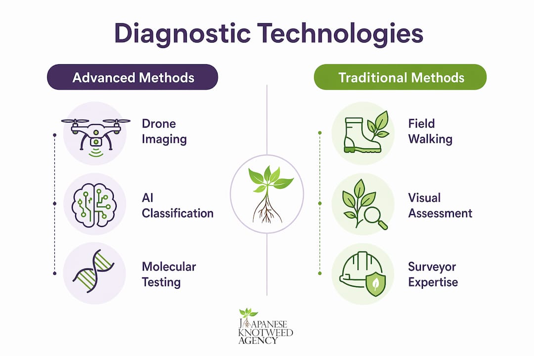
Drone-powered imaging is the most significant advance in weed detection of the past decade. Drones can map 1 hectare per minute at a ground sampling distance of 1.6mm, detecting weeds from the cotyledon stage onwards. That resolution means a plant the size of a thumbnail is visible before it establishes a root system capable of causing structural damage.
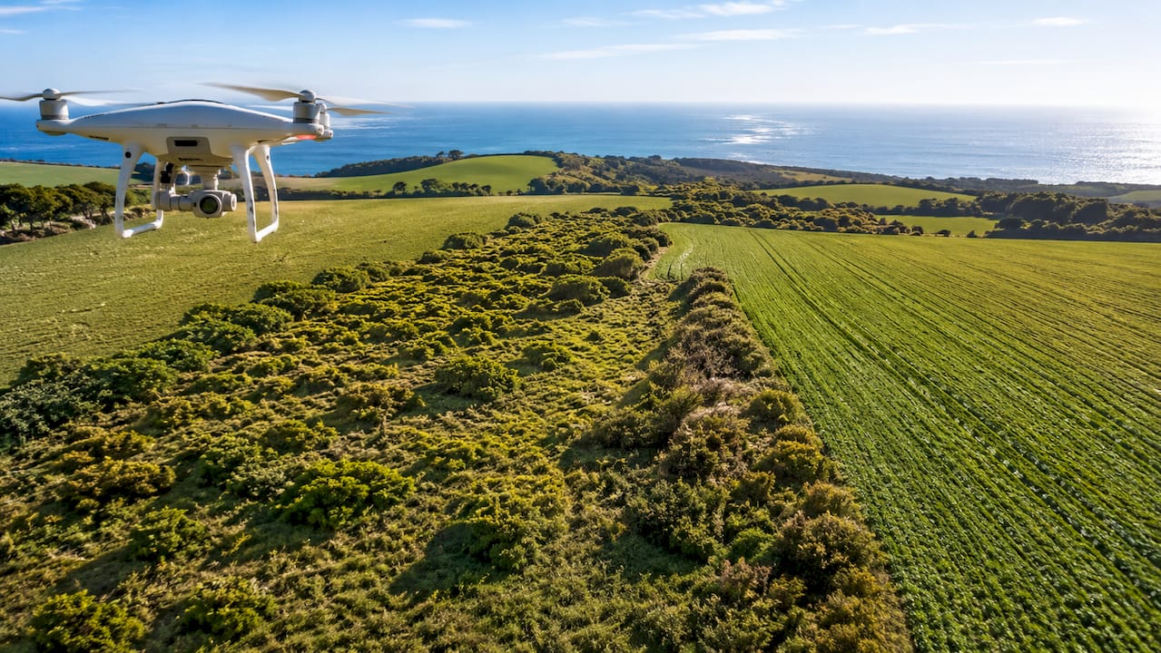
Satellite imagery, by contrast, typically delivers around 3 metres per pixel and introduces time delays that make early intervention impossible. Drone resolution of 1.6mm to 35mm gives land managers a detection window that satellite data simply cannot provide. For Japanese Knotweed, where rhizome spread can extend 7 metres from the visible crown, early detection is the difference between a contained treatment programme and a full excavation.
AI and machine learning for species classification
AI algorithms trained on annotated plant imagery classify weed species from drone footage with accuracy that rivals experienced surveyors. One UK field trial achieved 93.5% classification accuracy using a Random Forest model, predicting herbicide savings of 75% for volunteer beans and 81% for dock weeds. Those figures reflect targeted spot management rather than blanket application across an entire field or site.
AI systems mark infested areas for map-based spot spraying, integrating with ISOBUS farm sprayers and standard precision agriculture equipment. This area-level targeting is practical for large landholdings and compatible with existing machinery. For property owners managing smaller plots, the same mapping outputs inform manual treatment plans and legal documentation.
Molecular diagnostics and herbicide resistance
Visual identification alone cannot detect herbicide resistance. Molecular tools such as qPCR identify resistance-conferring DNA markers rapidly, revealing whether a weed population will respond to a given treatment before resources are committed. This matters particularly where repeated chemical applications have created selective pressure on weed populations. Molecular diagnostics complement drone imaging by adding a biological layer of intelligence to the spatial data already collected.
Professional invasive species surveys in the UK integrate LiDAR, aerial photography, and GPS to produce multi-modal datasets. These datasets support planning applications, legal cases, and long-term management plans in ways that a single site visit cannot.
Pro Tip: Request that any diagnostic survey you commission produces a georeferenced map output. A georeferenced map can be submitted directly to a solicitor or mortgage lender as evidence of species extent and treatment progress.
What are the benefits of using advanced weed diagnostics?
The most direct benefit is a substantial reduction in herbicide use. Drone-based AI diagnostics reduce herbicide use by 70–90% compared with blanket treatment approaches. That reduction lowers costs, protects soil biology, and slows the development of herbicide resistance across a site.
For property owners, the legal and financial benefits are equally significant:
- Legal compliance: Accurate species identification supports obligations under the Wildlife and Countryside Act 1981 and the Infrastructure Act 2015, both of which impose duties on landowners regarding invasive non-native species.
- Planning applications: Mortgage lenders and local planning authorities increasingly require a professional invasive weed survey before approving transactions or development consent. Diagnostic data provides the evidence base those processes demand.
- Targeted treatment: Spot treatment guided by diagnostic maps protects non-target vegetation, watercourses, and neighbouring properties from unnecessary chemical exposure.
- Resistance management: By identifying resistant genotypes early, molecular diagnostic tools allow land managers to rotate treatment methods before resistance becomes entrenched across a site.
- Multi-year planning: Diagnostic outputs create a baseline record. Repeat surveys at defined intervals show whether a management programme is working, providing data that supports adaptive decisions rather than guesswork.
Dr Emmanuel Zuza and other researchers note that advanced diagnostics enable a shift from blanket herbicide treatments to targeted spot management, reducing chemical use and slowing resistance. That shift is not merely an environmental preference. It reflects a measurable improvement in management outcomes over time.
Misidentification without advanced diagnostics risks ineffective control and wasted resources. The UK Plant Health Plan 2026–2030 explicitly urges robust diagnostic protocols to prevent this outcome. For a property owner facing a knotweed encroachment dispute, a misidentification can have serious legal and financial consequences.
How do advanced diagnostics compare with traditional survey methods?
Traditional weed identification relies on field walking, visual assessment, and the expertise of the surveyor. That approach works well for established infestations with visible above-ground growth, but it fails at the margins where early intervention matters most.
| Method | Resolution | Speed | Resistance detection | Legal documentation |
|---|---|---|---|---|
| Drone with AI imaging | 1.6mm–35mm | 1 hectare per minute | No | Yes, georeferenced maps |
| Satellite imagery | ~3m per pixel | Delayed by days | No | Limited |
| Field walking survey | Variable | Slow, labour-intensive | No | Yes, written report |
| Molecular diagnostics (qPCR) | DNA level | Hours per sample | Yes | Yes, laboratory report |
Drone imagery identifies problems that field walking misses entirely. A surveyor walking a site in october, when Japanese Knotweed has died back, may see nothing. A drone survey conducted in the same period, combined with thermal or multispectral imaging, can still detect rhizome activity below the surface. That capability is particularly relevant for invasive weed monitoring programmes that must continue year-round.
AI models do require extensive local training data to maintain accuracy. Over 12,000 plants annotated across 5,000 images were needed to build one UK-specific model, with additional tuning for local soil and light conditions. That development cost means AI-based diagnostics are most cost-effective when deployed across larger sites or as part of a structured management programme rather than a one-off assessment.
Traditional surveys remain valuable alongside advanced methods. A written expert report from a qualified surveyor carries weight in legal proceedings that an algorithm output alone may not. The most effective approach combines both: drone or molecular diagnostics for detection accuracy, and a professional survey report for legal and planning purposes.
How can property owners implement advanced weed diagnostics?
A structured approach produces the most useful results. The steps below apply whether you are managing a residential garden, a commercial site, or agricultural land.
- Commission a professional survey first. A property survey for invasive weeds establishes the species present, the extent of infestation, and the appropriate diagnostic methods for your site. Japaneseknotweedagency carries out surveys across England, Wales, and Ireland.
- Request georeferenced mapping outputs. Ask your surveyor to provide GPS-referenced maps showing species location and density. These outputs are directly usable in planning applications and legal correspondence.
- Match the diagnostic method to the species. Japanese Knotweed requires a different diagnostic approach to, for example, Giant Hogweed or Himalayan Balsam. Drone imaging identifies extent; molecular tools confirm species identity where visual identification is uncertain.
- Integrate diagnostic results into a management plan. A diagnostic report without a treatment plan is incomplete. Use the data to define treatment zones, select appropriate methods, and set monitoring intervals. Japaneseknotweedagency’s chemical-free treatment options align directly with diagnostic outputs, targeting the rhizome network identified in survey data.
- Schedule repeat surveys at defined intervals. Invasive species management is a multi-year process. Annual or biannual surveys confirm whether treatment is depleting the rhizome network and provide evidence of progress for mortgage lenders or legal purposes.
Pro Tip: If you are purchasing a property, commission a knotweed survey before exchange of contracts. A diagnostic report at that stage protects you from inheriting an undisclosed liability.
For sites where reporting Japanese Knotweed to local authorities or neighbours is required, diagnostic evidence strengthens your position and demonstrates responsible land management. Professional pest and weed control services, such as those offered by Arsenal Exterminating, similarly emphasise the value of accurate identification before any treatment programme begins.
Key takeaways
Advanced weed diagnostics, combining drone imaging, AI classification, and molecular tools, delivers the accuracy and legal evidence that property owners and land managers need to manage invasive species effectively and cost-efficiently.
| Point | Details |
|---|---|
| Drone imaging outperforms satellites | Drones detect weeds at 1.6mm resolution; satellites deliver around 3m per pixel with time delays. |
| AI classification reduces herbicide use | AI-guided spot treatment cuts herbicide use by 70–90% compared with blanket application. |
| Molecular tools detect resistance | qPCR identifies herbicide-resistant genotypes that visual surveys cannot detect. |
| Legal compliance requires diagnostic evidence | Mortgage lenders and planning authorities require professional survey reports backed by diagnostic data. |
| Repeat surveys confirm treatment progress | Annual diagnostic surveys provide evidence of rhizome depletion for legal and financial purposes. |
Why I think most property owners commission diagnostics too late
Working in invasive species management, the pattern I see most often is this: a property owner discovers Japanese Knotweed during a sale, commissions a survey under pressure, and then faces a compressed timeline to produce evidence for a mortgage lender. The diagnostic work that should have happened at the first sign of unusual growth gets done in a crisis instead.
Advanced weed detection techniques are not expensive relative to the cost of a failed property transaction or a legal dispute with a neighbour. A professional survey with georeferenced mapping costs a fraction of what a boundary dispute or mortgage rejection costs in time and legal fees. The economics are straightforward.
What I find genuinely interesting about the current state of the field is how molecular diagnostics are changing the conversation about herbicide resistance. Land managers who have been applying the same chemical treatment for years are now discovering, through qPCR analysis, that their weed populations have developed resistance. That knowledge changes the entire management strategy. Without molecular diagnostics, those managers would have continued spending money on treatments that were not working.
The practical advice I give to every land manager is this: treat diagnostic surveys as infrastructure, not as a reactive expense. The data you collect this year becomes the baseline against which you measure progress next year. That baseline is worth more than any single treatment.
— Alan
Professional invasive weed surveys from Japaneseknotweedagency
Japaneseknotweedagency carries out professional invasive weed surveys across England, Wales, and Ireland, producing the georeferenced reports and management plans that property owners and land managers need for legal compliance and effective treatment.
Survey outputs integrate directly with Japaneseknotweedagency’s thermo-electric treatment programme, which delivers up to 5,000 volts directly to the rhizome network without the use of chemicals. For property owners seeking a complete eradication survey, the agency provides a clear pathway from initial identification through to confirmed control. Book a survey at japaneseknotweedagency.co.uk/book-a-survey to begin the process.
FAQ
What is the role of advanced weed diagnostics for property owners?
Advanced weed diagnostics identify invasive species accurately, produce legal-grade evidence for mortgage lenders and planning authorities, and guide targeted treatment programmes that reduce cost and environmental impact.
How accurate are AI-based weed detection systems?
UK field trials have recorded classification accuracy of up to 93.5% using Random Forest algorithms trained on locally annotated plant imagery. Accuracy depends on the quality and volume of local training data used to build the model.
Can drone surveys detect Japanese Knotweed when it is dormant?
Drone surveys using multispectral or thermal imaging can detect rhizome activity below the surface during dormant periods, providing detection capability that standard field walking surveys cannot match in autumn or winter.
Do I need a molecular diagnostic test as well as a drone survey?
Molecular diagnostics are most valuable when herbicide resistance is suspected or when visual identification is uncertain. For most property surveys, drone imaging combined with a professional written report is sufficient for legal and planning purposes.
How often should I commission a weed diagnostic survey?
Annual surveys are the standard for active management programmes, providing year-on-year evidence of treatment progress. Properties undergoing a sale or planning application may require a survey at any point in the calendar year regardless of season.